David and Cam Special Feature!!!

We’re sure you were all wondering what we (Cam and David) did after Jaryd went to go farming babacos. Wonder no more, because here are our adventures without Jaryd. Just so that nobody is confused, this took place from June 29 to July 17, we just aren’t as punctual about writing as Jaryd is.
After Jaryd left us, we spent a day exploring Lima before taking a night bus to Huaraz. In Lima, we saw some cool ruins, a pre-Incan pottery museum, a church with catacombs, (David’s favourite part was a stone cross, not all the bones and underground tunnels) and some cool water fountains.

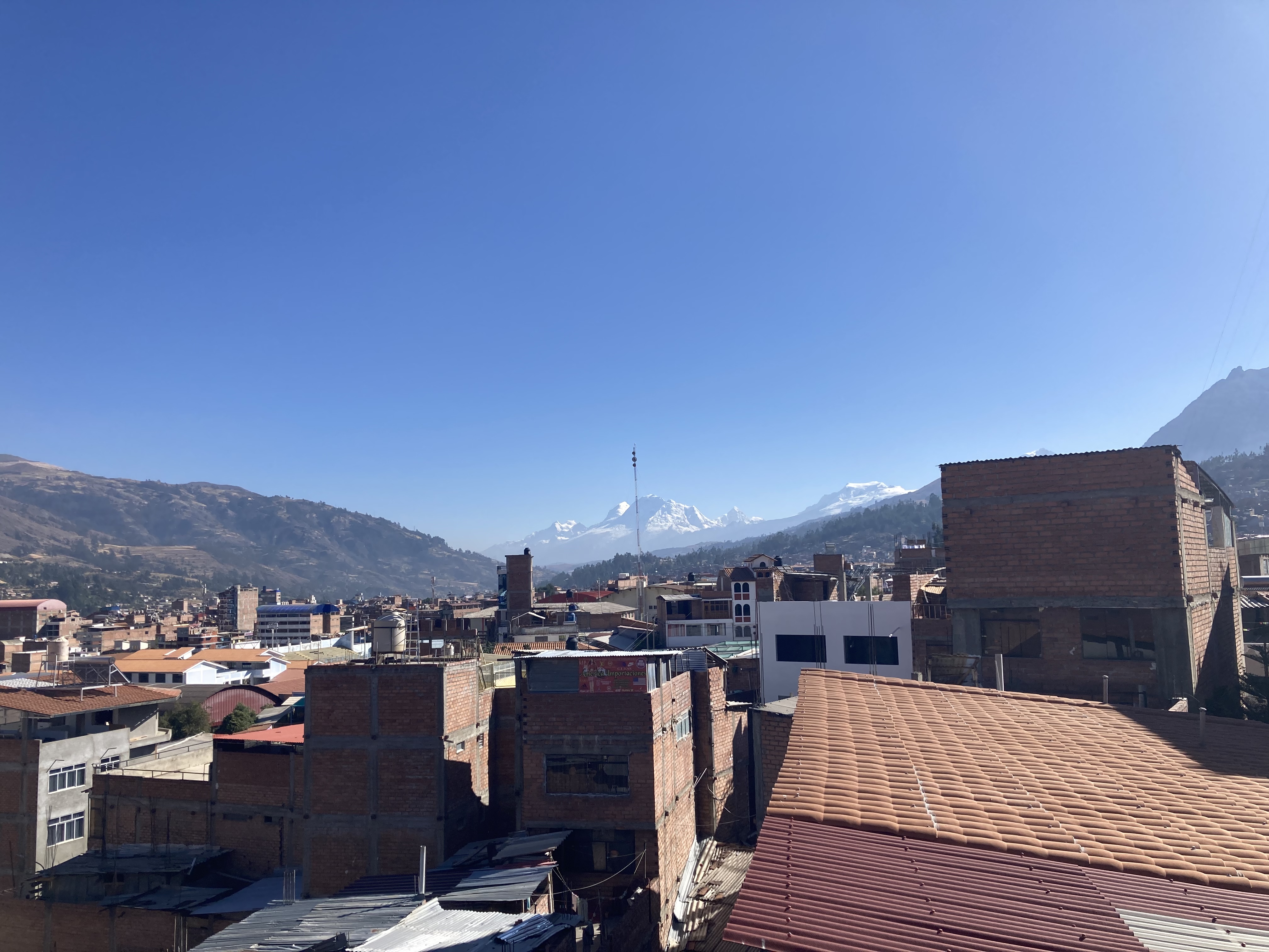
Huaraz
The city of Huaraz sits in a river valley at 3000 m above sea level, right next to the highest mountain range in Peru, the Cordillera Blanca, which reaches a massive 6768 m above sea level. This is the highest tropical mountain range in the world.
We spent our first day acclimitizing to the elevation, and on our second day, did an easy hike up to a lake called Laguna Churup, at 4500 m elevation. Cam called the lake “Laguna Churro” enough times that we both forgot the real name. At the lake, David took one of the best naps he’s ever experienced while Cam explored a smaller lake, cutely named “Churupita”.
The next few days were spent separately exploring and prepping for a multi day trek.


David’s Huaraz Solo Adventures
I decided to do a guided mountaineering trip up Nevado Mateo, a 5150 m tall mountain, just across the valley from Nevado Huascaran, the highest mountain in Peru. For reference, Mt. Robson, the highest mountain in the Canadian Rockies is only 3954 m tall.
I was joined in the tour by an Australian guy named Matt who I met in our hostel, and it was my first time trying to translate Spanish for someone else, because his Spanish is even worse than mine. Since joining up with Jaryd and Cam more than a month ago, I usually let them lead the conversations, but it’s encouraging to see that mine has also improved significantly.
We left the hostel at three in the morning, and were at Punta Olimpica Tunnel, the highest vehicle tunnel in the world before the sun rose. We slowly ascended steep rocky slopes, before reaching the bottom of a permanent snowfield. (Please note: there is a difference between permanent snowfields and glaciers. Glaciers move under their own weight and are much more hazardous than snowfields due to the deformation caused by movement) At this point, we all put on crampons, got out ice axes, and were roped together for the final ascent to the peak. We easily reached the peak, and enjoyed the views of the highest mountains in Peru for a half hour before descending again.
This was the highest mountain I’ve ever climbed, and the first time I’ve needed to use mountaineering equipment. I enjoyed the experience immensely, and was surprised by how well my body dealt with the altitude.


Cam’s Huaraz Solo Adventures
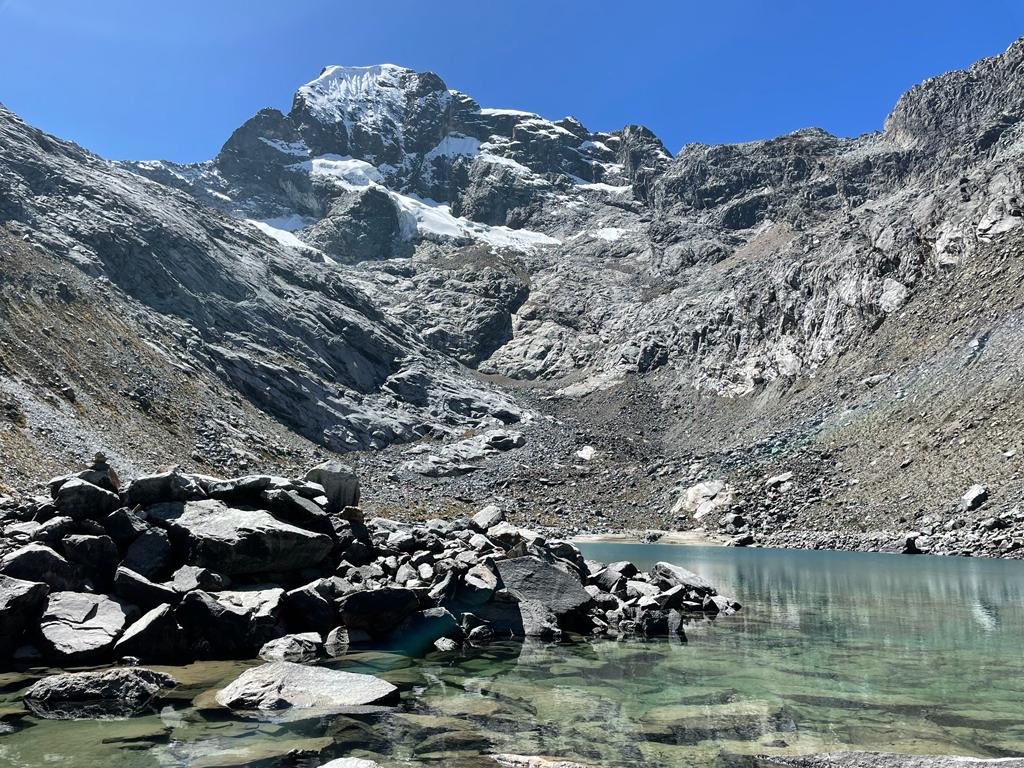
As a separate note, I visited Churrupita lake on our second day in Huaraz. I want to put a picture here because it was the best kind of glacial turquoise.
On the day David was going to go mountaineering, I was going to take the day to rest and visit the museum… which happened to be closed on the only day of the week I wanted to go. So I found a hike to do instead! I found a collectivo that would take me to the trailhead, and I caught the first one at 7 in the morning. I met three other hikers in the van, a local couple from Huaraz and another traveler from my hostel named Hazel. The hike is called the Circuit of the three lagoons, a slightly lesser known hike that can get lost among the many lake hikes around Huaraz. It is also a very long day hike at 23 km in length and 1.7 km of elevation. The local couple did the hike counter-clockwise, and Hazel and I did it clockwise. At the start of the day I did not intend to do the full loop, because I had told our friend Aviv at the hostel that I would be back by 4pm to plan for our upcoming Santa Cruz trek. I would be five hours late for that deadline.
The hike was absolutely stunning. We slowly climbed around the shoulder of the peak pictured above as the sun was rising. Green-yellow hills turned into a forest wrapping around the Laguna Radian. A group of Puna Ibis were wading in one corner of the lake. The surface reflected the Cordillera Blanca mountain range behind it beautifully.
A line of trees led us to our first switchback. Climbing up over the next shoulder we got to look into the valley we would follow up to the pass. The base of the valley was flat, with creeks cutting curved webs into the ground. The trail traversed the flank, following an irrigation channel or aqueduct that was guiding water to some of the farmland further down. Eventually the trail centered in the valley, and we were treated to a series of waterfalls, as well as a brutal and never-ending switchback into the alpine.
Things slowed down tremendously as the air got thinner, and a few hours later we reached the next lakes, Carhuac and Mullaca. These were the rewards for our hard work. Glacier water poured in from glistening waterfalls at every angle, the glacier itself capping the view at the back. On three sides the lakes were encircled by smooth white to sharp orange mountain tops. On the fourth side was still the view of the far-off range. We enjoyed it for as long as we could, but there was a pass to climb through and I knew I would be late by now.
This climb was slower and steeper still, as the rocks turned from orange to deep reds and blacks. Reaching Zorro pass was yet another astounding sight. The view behind remained, and rolling waves of red and orange rock coated the south side of the ridge. Also, at the exact highest point we ran into the local couple as they were hiking in the opposite direction. We took pictures and gave them one of our water bottles since they’d run out of water on the way up. We had to follow rock cairns down the opposite side since no trail stood out in the smoothed iron veins.
On the far side we moved through a maze of the mars-like terrain. Green hills reappeared as we descended towards the final lake, laguna Ahuak. The long descent down the mountain from there got us back to the village at the trailhead. We narrowly missed the next collectivo heading back to Huaraz from the village and had to wait for the next one, ensuring that we would get back to the city well after dark.


Santa Cruz Trek
We decided to do the popular Santa Cruz trek, a 43 km long trail, in 3 days. You can do the hike with a tour group if you want a 4 day fixed schedule, meals prepared for you, and most of your stuff carried by donkeys. We opted to do it unguided to give us more flexibility. We joined up with two Israeli guys, Aviv and Ayten, for the trek. The trek follows the Paria valley to Punta Union pass, at 4750 m, then down the Santa Cruz valley to the village of Cashapampa.
The first day started with a 5 am taxi pickup, and a 4.5 hour drive on rough roads to the trailhead. We then hiked through a quaint village on the mountain slopes before reaching the national park boundary and beginning the real trek. We hoped to reach the pass on the first day, but that goal turned out to be a little overambitious, so we camped high in the valley below the pass.
We awoke the next day to the refreshing sound of cows (David’s best friends) snuffling outside our tent, and we were able to reach the pass by mid morning. We descended from the pass, ate lunch, and then dropped our heavy packs and took a side trail up to Laguna Arhuaycocha, a stunningly blue lake with glaciers calving directly into the water. We both had a wonderfully refreshing dip in the lake, watched by Aviv and Ayten, then descended back to the main trail and made dinner. After dinner, we hiked for another 2 hours by starlight (and occasionally headlamps when we lost the trail) and then set up camp when we were too tired to continue.
On our final morning, we woke up to the beautiful sight of a lake and waterfall we had not seen in the darkness the night before, and then started the straightforward 17 km slog down the valley to the village of Cashapampa, where we caught a collectivo back to Huaraz.


David’s Santa Cruz Highlights and Reflections
Despite my preconceptions that since the hike did not include climbing any mountain peaks, it would be lame, this trek is easily in the top 5 backpacking trips I’ve ever done. I really enjoyed seeing the landscape change from idyllic mountain villages to barren alpine rock, and then back again, always with the backdrop of towering glacier-clad peaks. The cows forcing me to be their friend was also very fun, and definitely solidifies my love for them as one of the best animals in the world.

My two biggest highlights from the trip, however, were my gourmet breakfast on day 2, and the swim in the glacial lake. The breakfast consisted of tortilla, mayoqueso, salami and avocado, served in a stunning alpine environment. I discovered mayoqueso immediately prior to this trip and it is one of my new favourite things, but the addition of avocado elevated it to an entirely new plane of cullinary delight.
The dip in Laguna Arhuaycocha was immensely refreshing, and was my first time swimming in cold water on this trip. I used to jump in every body of water I could find, but have found that in recent years I have lost my nerve a little. It’s encouraging to see that I still have it in me to be a real Canadian and jump into the glacial waters.

One final aspect of the trek I found extremely neat was being able to observe the geomorphic changes in the valley, especially on the third day. The high valleys above about 3700 m elevation were clearly glacially carved, with wide, flat bottoms and steep sides. In these areas, you can clearly see where landslide processes have occurred in the recent post-glacial past, forming large alluvial fans, some of them damming lakes in the valley. Further down the valley, it becomes clear that the valleys were carved by rivers, with valley walls falling steeply into the river. Here, landslides are still obviously occurring (and probably more often) but their mark is less clearly seen because there is no space in the valley for debris to rest, so it is taken downstream instead of being deposited immediately in the valley bottom. From these observations, I would infer that during that last glacial maximum, glaciers in this area reached down to about 3700 m above sea level. I love being able to look at the landscape and see things like this.


We stayed in Huaraz for one night after the trek , then caught a night bus back to Lima and a flight to Chachapoyas.
Chachapoyas
Chachapoyas is a small city in Northern Peru, in a part of the Andes known as the Cloud Forest, in the transition zone from low altitude jungle and high mountains.

The day after we arrived, we took a tour to see some really cool ruins built into the side of a cliff, called the Mausoleo de Revash. Apparently, the people who built this were able to avoid being conquered by the Incas until the Spanish arrived due to the fact the they built their settlements on the tops of mountains. It’s hard to imagine successfully conquering this place if anyone was trying to defend it.
We hiked quickly to the ruins, and were able to go through a fence and get up close with the ruins before anyone else got there.


The tour also took us to a museum where there were a bunch of mummies, made by the same people group. Cam loves the mummies while David was pretty disgusted.
Gocta Falls
The next day, we went to one of the tallest waterfalls in South America, Gocta Falls. The falls drop 771 m in two different falls into the valley, and a 2 hour hike takes you to the base of the lower falls. It’s incredible standing at the base the falls and watching the water fall for 20 seconds before it hits the bottom. We both went and took a shower under the waterfall, with the water pounding down on our heads. One cool thing is how much wind the falling water generates as it falls down. After the waterfall shower, we both spent a while fossil hunting in the rocks at the base of the waterfall, and found a bunch of fossilized shells.


That evening, we checked into the Gocta Lodge, easily the fanciest place we stayed on this trip. We greatly enjoyed our dinner, our 15 foot ceilings, and queen sized beds for each of us. We could only afford one night, but it felt like living in luxury. The next day, we spent most of the day relaxing, David sat next to the pool for several hours, and Cam did a little bit more hiking and saw some cool birds.

After one night in luxury at Gocta Lodge, we went back to Chachapoyas for one final night, before beginning our bus ride north to meet up with Jaryd.
One funny thing about Chachapoyas is that the tourism program at the local university had their students doing a project where they needed to survey tourists, so any evening we walked around the city, we would invariably be approached by local university students trying to survey us. It was really fun, but a little difficult since our Spanish is so limited and none of them spoke English.
The Journey North
We spent 4 gruelling days and nights travelling north, from Chachapoyas, Peru, to Lago Agrio, Ecuador, where we finally met up with Jaryd again! We spent 3 of the 4 nights on busses, and which is enough to make anyone exhausted.

Our first night bus ride from Chachapoyas to Chiclayo, a city on the coast of Peru, was uneventful, and we spent the day hanging out in the somewhat sketchy city.
The Accident
Our next bus, from Chiclayo, Peru, to Cuenca, Ecuador, was unfortunately very eventful. The bus left Chiclayo at 5:00 pm, and the first 7 hours were normal, with the unfortunate annoyance of poor movie choices played loudly in Spanish. Shortly after midnight, we had just stopped in the beach town of Mancora, and were settling down to try to sleep, when we felt the bus slam on the brakes, swerve wildly, hit the car in front of us with a big bang, then sway frighteningly as it went off the road. We had seats on the top floor of the double decker bus, and the swaying felt like the bus was going to tip on its side. Fortunately, nobody was terribly injured in the crash, although the people in the car were taken to the hospital.
After a while standing on the side of the road, the police and some local residents showed up, but we didn’t really have any idea what was going to happen. About 2 hours after the crash, another bus from the same company came by and picked us up. The next 4 hours were immensely uncomfortable. The bus was carrying far more passengers than it had seats, so we were crammed into the aisle, with a space only about 2x3 feet to ourselves. Fortunately, the border crossing into Ecuador broke the time on our second bus in half, otherwise it may have been totally unbearable. Somehow, both of us managed to get some sleep crammed in an upright position on the floor of the bus. Around 6 am, we had to transfer busses again, and this time we got seats on the bus, which took us to Cuenca at last.

The trip from Chiclayo to Cuenca lasted 16.5 hours, on 3 different busses, with parts of 10 different movies played on the bus tvs.
The next mishap
We spent the next night sleeping in a bed in Cuenca, a city that felt really cool and we both wish we were able to spend more time in. Unfortunately, we had a timeline to keep, so we took a bus to Quito the next morning. Fortunately, the bus did not crash this time, although it slid backwards while trying to take a detour around a landslide. We made it to Quito on the same bus, only to discover that Cam’s bag had been stolen from the compartments under the bus during the journey. Cam was understandably devastated and angry, but there was nothing we could do. We had no idea when it was taken, and no way of getting it back.
We had nothing else to do other than keep on going to our meet up with Jaryd in Lago Agrio, so we soon caught another night bus, and arrived in Lago Agrio without any more disasters, and met up with Jaryd just in time to take our tour of the Amazon!
I haven’t read Jaryd’s recent posts yet, so I don’t know what he wrote about Lago Agrio, but the city appears to have 2 main industries: Oil and Drugs. It’s 20 km from the border with Colombia, and is thus apparently a drug trafficking hub, with many news articles about people getting shot in the area. We fortunately did not experience this, and had a pleasant day and night there, with Cam replacing some of his stolen stuff before we ventured into the jungle.
The total stats from our bus journey north are as follows:
44.5 hours on the bus
6 different busses
3 nights spent on the bus
Way too many loud movies dubbed in Spanish
We hope you enjoyed reading about our adventures without Jaryd, and aren’t too confused by how late we are with posting this.
Jaryd's usual weekly post from today (August 5) can be found here!


Very fun to read and hear more details about your adventures. Thanks for the geology lesson. I would love to see the falls.Glad to hear you reignited your cold water nerve.
ReplyDeleteHow nice to read your posts! Your comments and photos are so interesting. The waterfall is so amazing, as are the mountains and lakes. Thanks for sharing. Glad both were not hurt in the accident, and Cam was able to replace lost items. Enjoy the final leg of your fantastic adventure!
ReplyDeleteThanks for posting all the great photos and commentary! What an adventure the 2 of you had! Glad you both enjoyed your hike/mountain climbing and are both ok from your 44.5 h on various buses. Enjoy the rest of your trip!
ReplyDelete